
GROUND PENETRATING RADAR

Ground Penetrating Radar (GPR) has a wide range of applications, ranging from utilities and bridge deck investigations for transportation projects, to identification and location of buried features for environmental and archaeological studies, to geophysical studies.
Effective use of this technology is determined by several factors, including soils and geologic materials, depth, and the nature of the structures and materials being located. KMA has three mobile GPS units that allows for a wide range of applications. All of our units are self-calibrating, have auto configuration, and depth calibration.
Multiple-Frequency GPR
The multiple frequency allows for a wide range of applications/depths, from very shallow bridge deck analysis to deep utilities locating. Single frequency is generally applicable to depths of five to ten feet, dual frequency to depths of eight to fifteen feet, and triple frequency to depths of fifteen to thirty feet.
500 Megahertz (MHz) System
This system is the most applicable to utility locating, with a range up to fifteen feet. It also has the widest range of uses, including utilities, drums, tanks, voids, geophysical barriers (strata/bedrock), law enforcement (forensics, etc.), and archaeological (burials and structures). This unit also features a folding rough terrain cart.
100 Megahertz (MHz) System
This system offers the greatest penetration and is most applicable to geotechnical and geophysical analysis. It is useful for location deep utilities, geophysical features, and deep buried foundations, tanks, and other structures. Though not as portable and light weight as the Multiple-Frequency and 500 MHz systems, this unit can be easily transported in a survey or utility van and carried by two persons.
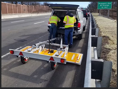
Kontur GPR
Kontur G2428 is a 3D GPR array with multi-channel (28 channels) Step frequency Ground
Penetration Radar (GPR) unit with frequencies ranging from 150 to 3000 MHz antennas. This unit
collects a swath of data approximately 6 feet wide; multiple passes will be required for the entire width of
the roadway with some overlaps. The data collected will be analyzed using Kontur’s Examiner software
to identify subsurface anomalies, including any buried structures loss underneath the pavement. These
features will typically be depicted as anomalies in the GPR cross-sections and the longitudinal profile.
The depth of penetration is anticipated to be 10-15 feet for the frequency range of the antenna systems,
depending on the subsurface materials encountered.
Impulse Radar Raptor 45
Impulse Radar Raptor 45 which is a 3D GPR array with multi-channel (18 channels) frequency Ground
Penetration Radar (GPR) unit with frequency of 450 MHz antenna will be used to locate any underground
utilities and to identify any voids that were caused due to the loss of soil around the culverts. With GPR
technology, these features will typically be depicted as anomalies in the GPR cross-sections.

